Conflict Prevention and Documentation of Shared Land Use
Land is a vital resource for both farmers and herders, serving as the foundation for livelihoods, food security, cultural identity, and economic survival. In many communities, farmland, grazing areas, water points, and migration routes are shared or overlap, often without clear agreements, records, or formally recognised arrangements. This lack of clarity contributes significantly to misunderstandings, competition, and recurring conflicts between farmers and herders.
The absence of systematic registration and documentation of shared land-use arrangements makes it difficult to determine who can use which land, when, and under what conditions. Informal practices, verbal agreements, weak record-keeping, and limited involvement of authorities further increase the risk of disputes, encroachment, crop damage, and retaliatory violence. These conflicts disproportionately affect vulnerable groups, including women, youth, and smallholder farmers, and undermine social cohesion, security, and local development.
Conflict prevention requires proactive, inclusive, and transparent systems for identifying, registering, and documenting shared land use rights and practices. By clarifying access rights, migration routes, grazing reserves, farming boundaries, and seasonal use arrangements, communities and institutions can reduce uncertainty, build trust, and promote peaceful coexistence.
This section of the guideline provides practical guidance on how communities, traditional institutions, women leaders, farmers, Herders, youths and relevant actors from both the formal and informal sectors can work together to prevent conflicts through participatory mapping, registration, documentation, and recognition of shared land use arrangements. It emphasises people-centred, gender-sensitive, and locally legitimate approaches that strengthen accountability, promote fairness, and support sustainable and peaceful management of land and natural resources.
The guidelines are informed by 66 Key Informant Interviews (KIIs) with diverse stakeholders (traditional/religious leaders, justice actors, farmer/herder representatives, civil society, and local government) and a Focus Group Discussion with 12 subject-matter experts, providing a strong, locally-grounded evidence base.
"Best practices" here mean successfully applied approaches that demonstrate local legitimacy and lead to fair, timely, and durable outcomes. Each practice was assessed for effectiveness, inclusiveness, and relevance to Katsina's social and security environment.
These recommendations serve as a practical reference for stakeholders directly involved in land governance and dispute prevention, including traditional and community leaders, mediators, legal practitioners, religious leaders, local authorities, and development partners working on farmer-herder conflicts.
A. Facilitate Community-Agreed Grazing Routes and Corridors
Community-agreed grazing routes and corridors are commonly accepted pathways that enable seasonal livestock movement between grazing areas and water points while minimising encroachment on farmlands and settlements. They help balance livestock mobility with crop production and reduce land-use conflicts.
Communities should be supported to jointly identify and agree on grazing routes and corridors through inclusive dialogue involving farmers, pastoralists, traditional leaders, women, youth, and local authorities. Agreements should reflect seasonal movements, farming cycles, and customary land-use practices, clearly indicating access points, timing of use, and protected farming areas. Once agreed, routes should be explained in local languages, publicly communicated, and integrated into community agreements and local by-laws to promote shared responsibility and compliance.
Communities should begin by jointly mapping existing livestock paths, farmlands, water points, and conflict hotspots using participatory mapping and seasonal calendars. Routes should then be negotiated and agreed upon, with clear provisions for managing movement during planting and harvest periods and addressing accidental damage through dialogue. Agreed routes should be validated, made visible through community meetings or markers, and periodically reviewed to adapt to climate variability, land-use change, and emerging pressures, with monitoring linked to community-based early warning mechanisms.
Strongly Recommended
B. Develop and Publicise Seasonal Land-Use Calendars
Communities should be supported to collaboratively develop seasonal land-use calendars that clearly outline farming cycles, grazing periods, harvest times, fallow seasons, and transhumance movements, drawing on both local knowledge and observed climatic patterns. The process should be inclusive of farmers, pastoralists, women, youth, and other land users to ensure the calendars reflect diverse livelihood needs and customary practices. Once developed, the calendars should be explained in local languages, using simple visuals and culturally appropriate symbols, and displayed in accessible public spaces such as markets, community halls, religious centres, grazing areas, and local government offices. Seasonal land-use calendars should be used as practical planning and dialogue tools to enable anticipatory coordination among land users, reduce accidental encroachment, and prevent seasonal disputes, particularly during periods of resource overlap. To remain effective, the calendars should be periodically reviewed and updated by the community to reflect climate variability, environmental change, and shifting land-use patterns, and be referenced by traditional and local authorities in land-use planning and conflict-prevention efforts.
Recommended
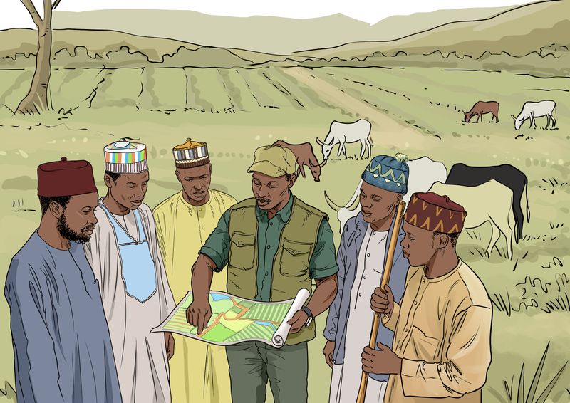
C. Apply Participatory Mapping for Farms, Water Points, and Routes
Communities should be supported to apply participatory mapping as a conflict-prevention tool to jointly identify and document farms, grazing areas, water points, stock routes, transhumance corridors, and other shared natural resources in areas experiencing pressure on land and water resources. The mapping process should be inclusive and dialogue-based, bringing together farmers, pastoralists, women, youth, traditional institutions, and local authorities to reflect diverse land-use practices, seasonal movements, and customary arrangements. Local knowledge of migration routes, dry-season grazing areas, and water access points should be combined with simple mapping techniques to enhance clarity and legitimacy, while respecting customary land rights and existing legal frameworks. Once validated, participatory maps should be explained in local languages and displayed in accessible public spaces to promote transparency and shared understanding. These maps should be used as practical reference tools for land-use planning, early warning, and mediation, helping to protect critical corridors and water points, reduce accidental encroachment, and manage seasonal overlaps. To remain effective, participatory maps should be periodically reviewed and updated to reflect climate variability, population growth, infrastructure development, and evolving land-use patterns, and should be formally referenced in community agreements, local by-laws, and state-supported conflict-resolution mechanisms.
Recommended
D. Establish Community-Based Early Warning and Early Response (EWER) Systems
Community-based Early Warning and Early Response (EWER) systems are locally driven processes that help communities recognise and respond to early signs of tension around land, water, grazing routes, and crop damage before they escalate into violence. These systems are built on trust, shared responsibility, and timely communication, enabling farmers and herders to protect both their livelihoods and their relationships.
Communities should be supported in designing and managing EWER systems that reflect their own realities and communication practices. Farmers, herders, women, youth, traditional leaders, and local authorities should all be involved in identifying what signals rising tension, who should report concerns, and how responses should be triggered. Emphasis should be placed on rapid dialogue, mediation, and practical adjustments, such as temporary access changes or joint problem-solving, rather than on punishment or force.
In practice, EWER systems begin with community discussions to identify common early warning signs, such as repeated crop damage, blocked stock routes, unusual livestock movements, water shortages, or rising verbal threats. Communities then agree on trusted focal persons or small groups who can receive and verify reports and share them through familiar channels such as phone calls, community messengers, or local meetings. Clear response pathways should be established so that once a warning is raised, elders, mediators, or peace committees can quickly convene dialogue between affected parties. Regular reflection and adaptation of the system help ensure it remains relevant as seasons, livelihoods, and environmental conditions change. When rooted in local relationships and ownership, EWER systems empower communities to act early, reduce fear, and build confidence in peaceful solutions.
Strongly Recommended
E. Document Customary Access Rights and Obligations
Customary access rights and obligations refer to locally recognised rules that govern who may use land and natural resources, when and how they may be accessed, and the responsibilities that accompany such use. These rules often balance rights to access with duties such as preventing damage, respecting routes, and compensating for losses.
Practitioners should support communities in jointly identifying and documenting customary access rights, along with the corresponding obligations that guide responsible land and resource use. This may include conditions for grazing access, seasonal restrictions, compensation norms for crop damage, responsibilities for maintaining routes and water points, and expectations for respectful conduct between land users. Documenting obligations alongside rights promotes fairness, accountability, and mutual respect, and helps prevent misunderstandings that can lead to conflict.
Communities should begin by facilitating inclusive discussions with farmers, pastoralists, traditional leaders, women, youth, and local authorities to identify existing customary rules in practice. Agreed rights and obligations should be clearly recorded in simple language, validated through community dialogue, and explained in local languages. The documented agreements should be publicly accessible, referenced in community by-laws and mediation processes, and periodically reviewed to reflect seasonal changes, evolving land-use patterns, and emerging challenges.
Recommended
Best Practices for Prevention
- Katsina State prioritises conflict prevention, especially during planting, harvest, and livestock migration, recognising that timely action is crucial to prevent harm and the escalation of disputes. Respected local actors, ward heads, elders, and religious figures intervene immediately using their authority and influence. This swift, trusted human intervention is valued as "justice," preventing rumours, reducing anger, and ensuring resolution before formal procedures are required. In Accordance with Literature Research
- Practitioners should include religious leaders as core preventive actors, providing orientation on conflict sensitivity and dialogue skills while allowing them to communicate in familiar religious language. Rather than replacing these approaches with purely technical messages, interventions should support faith-based communication that communities already recognise as legitimate and influential. Other Practice
- Practitioners should support periodic community dialogues to restate these norms in clear Hausa language and encourage their public announcement in markets, mosques, and other gathering spaces. The goal is to clarify and strengthen existing community agreements, rather than replace them with externally designed rules. In Accordance with Literature Research
- When an incident is reported, elders and trusted assessors quickly organise and conduct a joint inspection of the farm or grazing area. By observing the situation together, they determine whether the damage was accidental, minor, or intentional. This early verification reduces rumours, calms emotions, and discourages youth mobilisation for retaliation. The community treats fact-finding as a cooling and clarification process rather than a punitive investigation. In Accordance with Literature Research
- Seasonal movement of herders in Katsina often causes conflicts due to unfamiliarity with local routes and expectations, not deliberate violation. Communities, through Ardos, market leaders, and water-point caretakers, brief newcomers on approved cattle paths, emergency contacts, and expected conduct. Practitioners should establish simple orientation pathways at entry points and markets using verbal briefings and local signs. Interventions should view migrants as partners to inform, not suspects to control, fostering cooperation and preventing disputes. In Accordance with Literature Research